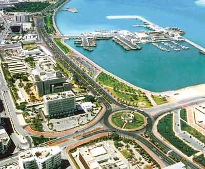
tourisem in london
Dates & Garden
10.00 - 5.30 m / of the date (03/10 to 10/26)
10.00 - 4.30 m / of the date (10/27 to 11/02)
10.00 - 4.00 m / from the date (11/03 to 03/09)
Last time to enter the park an hour before the closure date
In the holidays and weekends close the park will close at 6:00 pm
Ticket prices
Adult £ 12 = 74 Real
Children (3-15 years) 9 £ = 55 SR
Children younger than 3 years are free
Students / disabled / retired £ 10.20 = 63 SR
Family ticket 2 adults +2 small or 1 large +3 small = 38 £ / 235 SR
Address Garden
Regent Park
Outer Circle
Regent's Park
London NW1 4RY
Big Ben and Parliament Square Big Ben
Ppalarba famous clock faces and the biggest in Britain to rise about 320 feet (106 meters) and dubbed St. stepfen's Tower
It is part of the parliament building and return the name of the Big Ben bell to the huge weight of up to 14 tons and the hour is open to visitors ..
And ringing the bells in every quarter of an hour
And the nearest train station ground to reach the hour is station westminste
About London
London is the capital of the United Kingdom and its largest city. Located on the River Thames in southern England. Live in the city, about 7.5 million people, of whom about 2.7 in the neighborhoods of Inner London. With a population of around 12,599,561 people (Statistics 01/01/2005), making it the largest city in Europe (excluding Russia and Turkey) and one of the most important centers of political, economic and cultural rights. The form of the current administrative division of London in the first of April 1965 with the establishment of Greater London. The city has a large number of universities, institutes, museums and theaters. Take as many international organizations and international companies based in the city.
Al [show]
1 Geography
2 Administrative division
3 Culture and sightseeing
4 Economy and infrastructure
5 Universities
6 References
7 sites for Foreign Affairs
[Edit] Geography
Site for London in London Angletratmtd a distance of about 40 km on the banks of the River Thames and an average height of 62 meters above sea level. The city was founded originally on the north bank. Bridge was the Tower of London over many centuries the only bridge that connects both sides of the city together. The center of the city, business district and important streets on the north bank of the River. With the construction of other bridges and extending rail lines, the city expanded in all directions. The nature of London is generally flat. The River Thames in the past, present than it is now, where they were building a number of dams on it. Because of its proximity to the North Sea was subject to London for a number of floods. Been identified geographical longitude which passes the Royal Astronomical Institute (Royal Observatory) in Greenwich cm line number is zero. It is the day the line is calculated on the basis of different time zones in the world.
Reside in the area of the city climate moderate. Summer is usually warm and winter is cold but the temperature of not less than zero Celsius. The month of July is the hottest months, with an average temperature about 16.3 degrees Celsius while it is 3.9 ° C in the month of January, which is the coldest months throughout the year. Recorded in London in the summer of 2003 the highest temperature in the history of the city, then hit 37.9 degrees Miwip.
Featured Hotels in London
St Giles Hotel & Leisure Club
Tuesday, February 8, 2011
tourisem in qatar
tourisem in qatar
The most important tourist sites
- Sealine Beach Resort:
In place of sweet sports village: What became the masters ..
The possibility of sweet and our Tmchaih if you have children, in the sweet seats and views
Major Cities
Doha:
Doha is situated, the capital, on the outskirts of a calm bay halfway the east coast of the peninsula, and is inhabited by 83% of the population in both Doha and Rayan suburb, is also the commercial and cultural center of the country.
Al Wakra:
A small town located on the coast halfway between Doha and Mesaieed. A trading center and a thriving fishing port which is still used today. The city is famous for its beautiful mosques and many houses built on ancient Islamic architecture. There is also a museum housed in galleries display traditional Arab gates and other artifacts.
Creek:
The city of Al Khor north of Qatar at a distance of 57 km from Doha. Until the early forties of the last century, a thriving port and center for the pearling industry. Although other industries are beginning to replace those industries now, but that the city teems with history on the ancient mosques and beautiful museum that houses artifacts and valuables as well as the historic towers.
Site
Qatar is a peninsula located in the middle of the west coast of the Arabian Gulf, followed by a number of islands, the most important islands: Halul, Shira'aw and Alozhat, and others. Its topography consists of a rocky flat surface with some hills and limestone outcrops in Dukhan area in the west and Mount Fuwairit in the north and the advantage of this surface frequently bays and bays and ponds and depressions called (Riyadh) and reside in the north and central part of the most fertile sites in which there were plants natural.
Back to top
Space
The area of the State of Qatar (11 521) square kilometers.
Population
Exceeds the population of the State of Qatar (800) thousand people, half of whom live in the capital city of Doha.
DC
Doha.
Language
Arabic the official language of the country.
Religion
Islam is the official religion of the State of Qatar, the Islamic Sharia is the main source of legislation in the country.
Climate
Qatar has a desert climate with hot summer and warm winters of little rain.
Qatar stadiums in the 2022 World Cup
The most important tourist sites
- Sealine Beach Resort:
In place of sweet sports village: What became the masters ..
The possibility of sweet and our Tmchaih if you have children, in the sweet seats and views
Major Cities
Doha:
Doha is situated, the capital, on the outskirts of a calm bay halfway the east coast of the peninsula, and is inhabited by 83% of the population in both Doha and Rayan suburb, is also the commercial and cultural center of the country.
Al Wakra:
A small town located on the coast halfway between Doha and Mesaieed. A trading center and a thriving fishing port which is still used today. The city is famous for its beautiful mosques and many houses built on ancient Islamic architecture. There is also a museum housed in galleries display traditional Arab gates and other artifacts.
Creek:
The city of Al Khor north of Qatar at a distance of 57 km from Doha. Until the early forties of the last century, a thriving port and center for the pearling industry. Although other industries are beginning to replace those industries now, but that the city teems with history on the ancient mosques and beautiful museum that houses artifacts and valuables as well as the historic towers.
Site
Qatar is a peninsula located in the middle of the west coast of the Arabian Gulf, followed by a number of islands, the most important islands: Halul, Shira'aw and Alozhat, and others. Its topography consists of a rocky flat surface with some hills and limestone outcrops in Dukhan area in the west and Mount Fuwairit in the north and the advantage of this surface frequently bays and bays and ponds and depressions called (Riyadh) and reside in the north and central part of the most fertile sites in which there were plants natural.
Back to top
Space
The area of the State of Qatar (11 521) square kilometers.
Population
Exceeds the population of the State of Qatar (800) thousand people, half of whom live in the capital city of Doha.
DC
Doha.
Language
Arabic the official language of the country.
Religion
Islam is the official religion of the State of Qatar, the Islamic Sharia is the main source of legislation in the country.
Climate
Qatar has a desert climate with hot summer and warm winters of little rain.
Qatar stadiums in the 2022 World Cup
Tourism in India
Tourism in India
To India: from the river Indus (Sindh) India derives its name, and appeared Land and India, the land on which their meaning is located beyond the Indus, and the people of this country's so-called Indians or Hindus. And is also likely to derive a name from the name of God (Andhra)
Population: one billion and 27 million and 15 thousand and 247 people.
Area: more than 3 million square kilometers.
Languages: 17 major languages and 844 dialects.
But the language that links the Indian economic and political language is English
Major religions: Islam, Hinduism, Christianity and Buddhism, Sikhism and Gangep (relative to the river Ganga)
National anthem: his name (Jean Gana Mana) and written by Tagore Rabindr
National Animal: Tiger.
National Bird: Peacock.
National Flower: Lotus.
National tree: tree (Banyan).
National fruit: mango.
National sport: hockey.
National Currency: Rupee.
Republic of India (Hindi: भारत गणराज्य) is a country in South Asia, including most of the Indian subcontinent. India's coastline stretches for more than 7000 km, its neighboring Pakistan and Afghanistan from the north-west, China, Nepal and Bhutan to the north, Bangladesh and Myanmar to the east. In the Indian Ocean, Maldives Thavea from the south-west, the south of Sri Lanka, and Andenossia from the south-east. India is the second largest country in the world in terms of population, a population of over one billion people today, and is ranked seventh in the world in terms of area
India knew that some of the earliest civilizations witnessed the ancient world, as has been the center of many important trade routes throughout history, has also at home five of the major world religions: Hinduism, Buddhism, Jainism and Sikhism. Was formerly part of the territory of the British Crown, before riding it in 1947, known as India's significant growth in the field of economy during the ten-years, have also come to play a greater role in the region and the world.
Geography and climate
The series of Himalayan terrain, most of the northern states and eastern India. Formed the rest of the Northern States, Central and Eastern fertile plains (plains of Sindh - King). Stretching desert, "Tar" in areas of eastern India, near the Pakistani border. The southern regions of the country consists mostly of the Deccan Plateau. Takes two strings plateau of hilly coast, "Cat Bank" and "Cat" East.
Presence of many large rivers in India, most notably the Ganges, Brahmaputra, Yamuna, Krishna and Godauari. This is why the first rivers in the Northern Plains fertilization is thus contribute to the country's agricultural activity.
India's climate varies from tropical in the south to temperate in the north. There is a harsh environment (climate tundra) in northern areas near the Himalayas. Rainfall is abundant during the monsoon storm.
^ Qutb Manar (Delhi): The beacon based unique of its kind, dating back to the era of Almmlik, Sultans of Delhi
^ ^ the Himalayas in Jammu and Kashmir, following the eastern border of India topography of these mountains
A group of pictures of the temples in India
tag mahal
To India: from the river Indus (Sindh) India derives its name, and appeared Land and India, the land on which their meaning is located beyond the Indus, and the people of this country's so-called Indians or Hindus. And is also likely to derive a name from the name of God (Andhra)
Population: one billion and 27 million and 15 thousand and 247 people.
Area: more than 3 million square kilometers.
Languages: 17 major languages and 844 dialects.
But the language that links the Indian economic and political language is English
Major religions: Islam, Hinduism, Christianity and Buddhism, Sikhism and Gangep (relative to the river Ganga)
National anthem: his name (Jean Gana Mana) and written by Tagore Rabindr
National Animal: Tiger.
National Bird: Peacock.
National Flower: Lotus.
National tree: tree (Banyan).
National fruit: mango.
National sport: hockey.
National Currency: Rupee.
Republic of India (Hindi: भारत गणराज्य) is a country in South Asia, including most of the Indian subcontinent. India's coastline stretches for more than 7000 km, its neighboring Pakistan and Afghanistan from the north-west, China, Nepal and Bhutan to the north, Bangladesh and Myanmar to the east. In the Indian Ocean, Maldives Thavea from the south-west, the south of Sri Lanka, and Andenossia from the south-east. India is the second largest country in the world in terms of population, a population of over one billion people today, and is ranked seventh in the world in terms of area
India knew that some of the earliest civilizations witnessed the ancient world, as has been the center of many important trade routes throughout history, has also at home five of the major world religions: Hinduism, Buddhism, Jainism and Sikhism. Was formerly part of the territory of the British Crown, before riding it in 1947, known as India's significant growth in the field of economy during the ten-years, have also come to play a greater role in the region and the world.
Geography and climate
The series of Himalayan terrain, most of the northern states and eastern India. Formed the rest of the Northern States, Central and Eastern fertile plains (plains of Sindh - King). Stretching desert, "Tar" in areas of eastern India, near the Pakistani border. The southern regions of the country consists mostly of the Deccan Plateau. Takes two strings plateau of hilly coast, "Cat Bank" and "Cat" East.
Presence of many large rivers in India, most notably the Ganges, Brahmaputra, Yamuna, Krishna and Godauari. This is why the first rivers in the Northern Plains fertilization is thus contribute to the country's agricultural activity.
India's climate varies from tropical in the south to temperate in the north. There is a harsh environment (climate tundra) in northern areas near the Himalayas. Rainfall is abundant during the monsoon storm.
^ Qutb Manar (Delhi): The beacon based unique of its kind, dating back to the era of Almmlik, Sultans of Delhi
^ ^ the Himalayas in Jammu and Kashmir, following the eastern border of India topography of these mountains
A group of pictures of the temples in India
tag mahal
tourisem in Germany
tourisem in Germany
Berlin (German: Berlin) is the capital of the Federal Republic of Germany, one of the states of Germany and the sixteen largest cities in Germany in terms of population and area. State is a "U.S. cities" of the three Federal Republic of Germany (in addition to Bremen and Hamburg). This label comes from the fact that the city limits are the same jurisdiction. Berlin is also the second largest city in the European Union after London.
During the Cold War, the Government of East Germany's construction of the Berlin Wall in 1961. Thus Berlin became a city divided into two parts, one follows the west of West Germany and one follows the east of East Germany. That remained the case until the fall of the Wall in 1989 and the unification of Germany in 1990. Now is the center of Berlin, the German government and parliament and one of the most important cities of Europe.
Wall Prlinprlin has three international airports: Tegel, Tmbelhov and Scheinfeld. Work is underway to expand the latter to relieve the pressure from the others and later to Iglagahm completely. Linked to the city to highways following: A10, A100, A111, A113, A114, A115. The city has a large network of trains and the metro, and also several stations, linking Berlin to the rest of the cities of Germany and Europe.
A snapshot of the night in Berlin Prlinlde several opera houses and several orchestras of their own. Olympic Stadium has been created specifically for the Olympic Games staged in 1936 was held in Berlin during the Nazi era. The match was the final of the 2006 World Cup in this huge stadium. TV channels Zat Ince, MTV Deutschland and many TV channels and other radio based in Berlin, the seat her. Conservative newspaper Die Welt, Berliner Zeitung, taz, and issued from Berlin.
Berlin (German: Berlin) is the capital of the Federal Republic of Germany, one of the states of Germany and the sixteen largest cities in Germany in terms of population and area. State is a "U.S. cities" of the three Federal Republic of Germany (in addition to Bremen and Hamburg). This label comes from the fact that the city limits are the same jurisdiction. Berlin is also the second largest city in the European Union after London.
During the Cold War, the Government of East Germany's construction of the Berlin Wall in 1961. Thus Berlin became a city divided into two parts, one follows the west of West Germany and one follows the east of East Germany. That remained the case until the fall of the Wall in 1989 and the unification of Germany in 1990. Now is the center of Berlin, the German government and parliament and one of the most important cities of Europe.
Wall Prlinprlin has three international airports: Tegel, Tmbelhov and Scheinfeld. Work is underway to expand the latter to relieve the pressure from the others and later to Iglagahm completely. Linked to the city to highways following: A10, A100, A111, A113, A114, A115. The city has a large network of trains and the metro, and also several stations, linking Berlin to the rest of the cities of Germany and Europe.
A snapshot of the night in Berlin Prlinlde several opera houses and several orchestras of their own. Olympic Stadium has been created specifically for the Olympic Games staged in 1936 was held in Berlin during the Nazi era. The match was the final of the 2006 World Cup in this huge stadium. TV channels Zat Ince, MTV Deutschland and many TV channels and other radio based in Berlin, the seat her. Conservative newspaper Die Welt, Berliner Zeitung, taz, and issued from Berlin.
Subscribe to:
Posts (Atom)